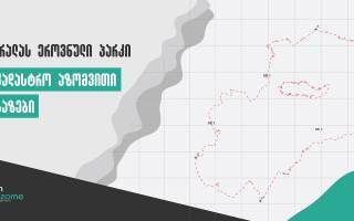
Preparation of demarcation and land registration documentation for Mtirala National Park
On the order of the Agency of Protected Areas, in the period of April - June 2022, we implemented the project of establishing the border and preparing the land registration documentation in order to improve the management of the park.
Within the framework of the project, in close cooperation with the administration of the Mtirala National Park, the border of the Mtirala National Park was clarified, non-typical infrastructure, territories owned by individuals and legal entities, as well as changed territories that have no conservation value or do not comply with the requirements of the law "On the System of Protected Areas" were excluded from the protected area - These areas are homesteads, orchards and others.
During the course of the project, field and camera works were carried out, which included taking new border markers in the field using GPS equipment and measuring the areas to be removed or added.
During the camera work, the necessary registration documents for registration in the new borders of the National Park, a detailed technical report of the border description and a demonstration topographical map of the National Park were prepared.
The territory of Mtirala National Park is located between the municipalities of Kobuleti, Khelvachauri and Kedi.
"Mtirala" is one of the outstanding and favorite places for visitors, where you can always go in search of adventure and discover interesting and beautiful places.